Q. Why was longitude boiling mad?
A. Because it was 360 degrees.
Cartographers are/were often seen as pretty dour characters. Not so long ago, maps were hand-drawn, and hanging over a drawing table, the meticulous of drawing contours seems rather nerdy. But, as programmers put easter-eggs in code, cartographers do the same.
Map makers sometimes put phantom streets, parks, ponds and such, in their maps, so as to trap others that copy their work. Copyright infringements will be unmasked by these fictional, deliberate trap streets, and this has been going on for hundreds of years.
The term paper street and trap street are often confused, but they can be interpreted as different things: Paper towns/street can be planned constructions that are never created, trap streets are included to trap other cartographers.
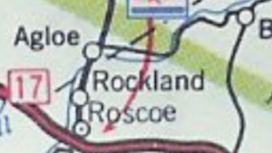
One of the most hilarious examples are the creation of the town Agloe in New York state. “Agloe” being a mashup of the
initials of Otto G. Lindberg and Ernest Alpers of the General Drafting Company. Their map was – according to them – then copied by a competitor a few years later. Digging into the matter, it turned out that in that once empty spot, a shop was built, now sporting the name Agloe General Store. It now exists, and you can look it up in Google maps.
Apparently, according to a spokesperson for the London A-Z, their maps include about 100 trap streets, and a fictional mountain peak went undetected in the US for two years.
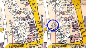
Owen Massey McKnight, clearly a map enthusiast, found a trap street in Oxford called Goy Close. He went to the scene and found it to be a backstreet of a backstreet.
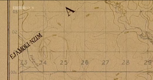
As for the easter eggs; in a British army map from the 20ties, a sweaty cartographer added an elephant outside the Gold Coast:
There is some potential for entertainment in trap streets. As mobile apps start showing you layouts of shopping centres (where to find a tin of tuna?), trap rooms or trap doors (haha) could be introduced. This would make for urban exploration, a kind of cartographic treasure-hunts. It might unnerve some people, but there is a long history for these sort of things in all sorts of contexts.
There are other examples of fictional entries in other works such as lists of names, magazines, dictionaries, medical books, a fictional mammalian order, a fictional star system and others. Not to mention Google maps. I will get back to this in another post, it is too funny to let lie.
It is curiously difficult to find information and examples of cartographic easter eggs and trap streets, any pointers you might have will be greatly appreciated.
Personally, I live in a street that on many maps do not exist. It is real, but many gps systems and paper maps have not caught up yet.
Nothing in this world is for certain.
Trinity says:
Love it! I’ve never heard of this, and it makes me curious to learn more!
boblet says:
It is interesting! But it is absurdly difficult to find good information about it… I would be happy to know of any, should you find some sources.
Trinity says:
I actually worked in the map department of BP as a teenager one summer, and I’d still never heard about trap streets before! Switzerland is probably the best-mapped country on the planet – I’ll be keeping my eyes out for the Easter eggs. I’ll let you know if I find any more information!
boblet says:
Very cool! It has been sitting in the back of my head for ages, and an episode of QI with the elephant in the map brought it to the front. I will be back with more cartographic and other diagram absurdities, but it is tough to find much on trap streets.
Trinity says:
Reblogged this on History Undusted and commented:
Here’s an interesting bit of history (and current) trivia for all you aspiring cartographers out there. Maybe your town’s map has a trap street…